Upgrade
Module for 2004 and Earlier Users (Item#B-02)
It
enhances your existing AIMS (that was delivered in or before 2004) to include
the new features as follows:
1. Plotting Collision Types In 3 Dimensions On
GIS Map:
§
You can plot different collision types in 3 dimensions on
GIS map, as shown Figure A-01B.
§
You can use different shapes, colors, and sizes of symbols
to denote different types of collisions.
§
You can label each plotted symbol with information from 1 to
10 fields in the accident record. For example, you can label each symbol with
year, injury, fatality, and pedestrian, as shown in Figure A-01C.
§
You can click a plotted symbol to see the detail accident
record, as shown in Figure A-01D.
§
You can assign a height factor to adjust the distance
between each stacked symbol.
§
You can adjust the angle of stacked symbols (90 degree to
stack vertically upward, 0 degree to stack horizontally).
§
If you order the Aerial Photograph Module (Item A-08), the
collision types in 3 dimensions can be plotted on aerial photograph (see Figure
A-08)
§
If you order the Accident Report Image Module (Item A-11),
when you click a plotted symbol, it will display the scanned accident report
image on the screen (see Figure A-11B).
2. You can draw polygons of any shape when
specifying areas on the map; in additional to drawing rectangles and circles,
hence it will be easy to specify any odd-shaped locations for analysis.
3. When performing query, a) you can specify
intersections by clicking one or more valid intersection names from a dropdown
list; b) you can specify a main street name by clicking a valid street name
from a dropdown list, once the main street name is specified, all valid cross
streets that intersect the main street will automatically be generated, you can
click one or more valid cross streets from the list; c) two boxes are available
for you to type the from date and to data; d) two boxes are available for you
to type the from year and to year; and e) you can save everything you have
specified for a), b), c) and d) in a file and then re-use it next time. As a
result, it will be easier to perform queries.
4. You can plot results from further queries in
3 dimensions on GIS map. For example, you may specify an area on the map and
then plot the accidents in 3 dimensions on GIS map. After this, you may perform
further query to sort out the accidents involving pedestrians only. With this
update, you can plot the accidents involving pedestrians only in 3 dimensions
on GIS map. Similarly, You can perform additional queries and then plot the
query results out in 3 dimension on GIS map. This facilitates user to create
scenarios and to plot them out to visually examine the traffic safety pattern
under various scenarios.
5. If you ordered the Collision Diagram Module
(A-02), this update module will enable you to label each collision with any or
all of the following: date, time, day of week, weather, pavement condition,
accident identification number, vehicle travel directions and collision type. The
label is in English description, because it converts the codes for weather,
pavement condition, vehicle travel directions and collision types into English.
(You can label each collision with collision type and travel directions first,
making sure that AIMS has plotted the collisions correctly, then re-plot the
collisions again with other labels for production purpose.)
Sample Outputs For Plotting Different Collision Types
In 3 Dimensions On GIS Map:
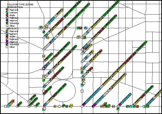
Figure A-01B: Plotting Collision Types in 3 Dimensions On
GIS Map
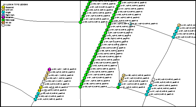
Figure A-01C: Labeling Each Plotted Symbol With Information
From 1 To 10 Fields, Such As Year, Injury, Fatality and Pedestrian
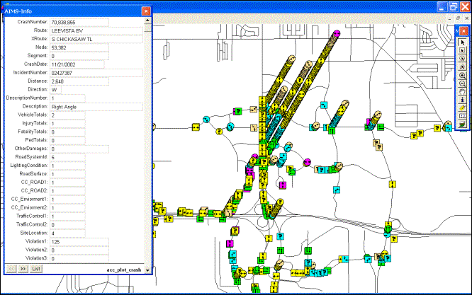
Figure A-01D: Displaying Detail Record Information Associated
With Each Plotted Symbol (After Clicking A Symbol)
|
Copyright © 2017, JMW Engineering,
Inc. All rights reserved. Protected by U.S. Patent
6104410 |